

CL: ATS

Intel of Note
The Importance of Having a Plan
Be Smart. Take Part. Prepare. - FEMA
Having a plan is essential to operations in general but especially important in the event of a “Black Swan” scenario. Black swans are events that are extremely unlikely to happen but when they do they can have world & life-changing effects. To illustrate the importance of having a “endgame” plan as well as the depth that one should consider when developing such a plan we are going to take a brief look at the various Continuity of Government facilities that are located around the United States. The facilities will be listed in order of most likely to have been heard of to the least likely.
Cheyenne Mountain Complex
Coordinates - 38°44′33″N 104°50′54″W
The Cheyenne Mountain Complex is an underground bunker complex located within the Cheyenne Mountain Range in Colorado. It is located about a 100 miles south of Denver International Airport just outside the town of Colorado Springs. While it is no longer fully active in its heyday it housed some of the most important defense commands for the United States.
When active the complex housed vital U.S commands such as the United States Space Command (USSPACECOM) & its most famous tenet, the North American Aerospace Defense Command (NORAD). Since 2008 both commands as well as the United States Northern Command (USNORTHCOM) have been operating out of Peterson Space Force Base. Why? I’m not sure, as you will see the CMC is a hardened bunker who’s weakness would only come from within.
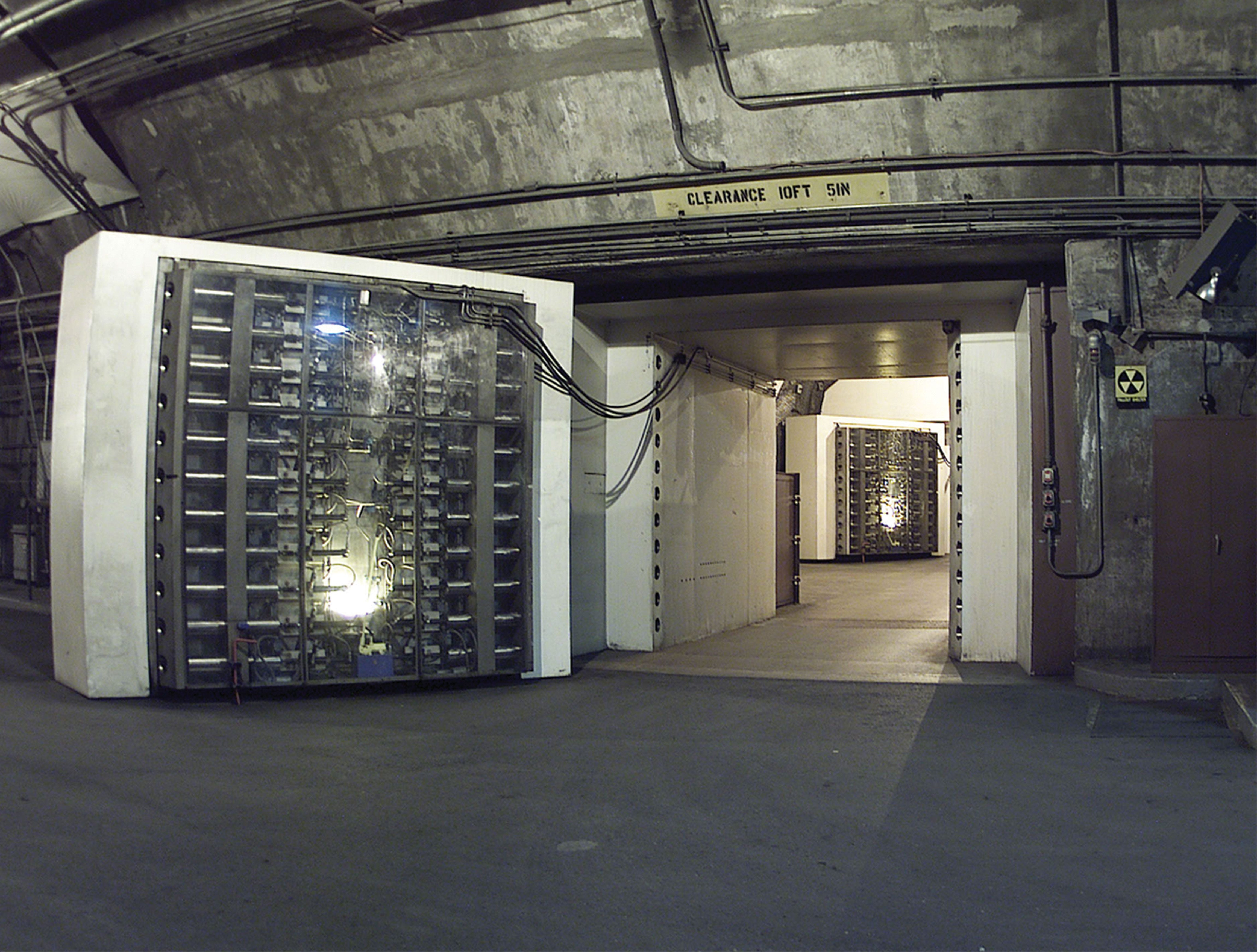
The complex is built to withstand a direct nuclear attack of up to 30 megatons. Within the complex are 15 three-story buildings that are placed atop giant springs to keep the buildings from moving. One of the more famous components of this system are the 25-ton blast doors used to seal off the complex. (pictured below) The complex is the only DoD facility that has the ability to withstand an Electromagnetic Pulse or EMP.
Because the CMC needs to be able to survive a various undesirable events & the aftermath of those events the site has its own power generators, water supply & heating/AC system. The complex has its own support unit dedicated to ensuring a 99.999% reliability of those systems under a myriad of events including natural disasters, civil unrest, cyberattacks, chemical attacks, EMPs & nuclear attacks.
Mount Weather Emergency Operations Center
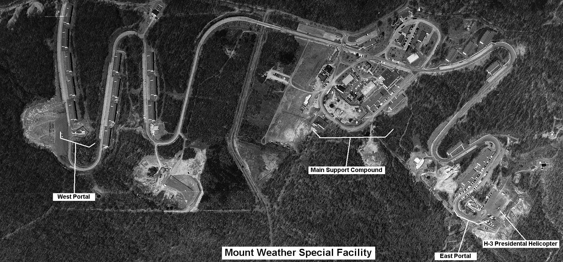
Coordinates - 39.063°N 77.889°W
The Mount Weather Emergency Operations Center is a secure communications outpost/bunker located in Virginia. It is the central hub for FEMA & consists of two sections: one above ground & one underground. The center is designed to connect the U.S military & other agencies via radio after a cataclysmic event. An interesting fact about the facility is that during events that call the majority of the U.S. Government to one location, such as the State of The Union or an Inauguration, a Designated Survivor is brought here incase of an attack on said event.
Raven Rock Mountain Complex
Coordinates - 39.729642°N 77.432468°W
The Raven Rock Mountain Complex or Site R is an underground facility similar to the Cheyenne Mountain Complex. Its purpose was/is to serve as the Alternate Joint Communications Center or AJCC. In layman’s terms it is to serve as the “underground Pentagon.” Site R is located within a mountain in the south of Pennsylvania.
Similar to the CMC it houses free-standing buildings within the mountain in order to shield them from the effects of a potential nuclear attack. It is also self-sufficient in that it has its own power & water supply as well as its own food reserves. Site R contains operations centers for almost all branches of the United States Armed Forces including the Army, Air Force, Marine Corps & Navy. The last known public acknowledgment of the facility was after the 9/11 attacks when the Vice President used Site R as a secure location away from the President.
Big Hole & Short Hill mountain
Many of our readers are AT&T Corporation customers but many are unaware of AT&T’s Top Secret involvement in emergency communications for the U.S Government in an end-times scenario. AT&T (also known as the Bell Telephone Company or Bell Labs depending on the operation) had a hand in communications between most of the sites listed above in one way or another.
There are numerous facilities dotted around the country that AT&T intended to have connect the DoD & it’s assets after the rest of us perished. The two more notable ones are Big Hole & Short Hill Mountain, both of which are located in Virginia. Similar to 33 Thomas Street in New York City (the interior of which is the cover photo for IB-001) AT&T is extremely tight-lipped about what these sites are & what their purpose is.
Big Hole
Big Hole is a Top Secret communications facility and bunker built during the Cold War. The facility is located in Chatham County, Virginia & its purpose was to serve as a part of a network of facilities designed to keep the Command & Control (C2) systems of the U.S. military operational in the event of a nuclear attack. This network of facilities was referred to as AUTOVON or the Automatic Voice Network. There are/were 60 of the facilities located around the United States with 20 of those facilities being hardened bunkers. According to an article written in 2000 the property is still owned by AT&T, the site was supposedly deactivated in 1996. However, another article written in 2018 claims the site is still active as AT&T Project Office NC-1.
Short Hill Mountain
The facility at Short Hill Mountain which is in Loudoun County, Virginia holds the same amount of mystique as Big Hole, but unlike Big Hole the mystery stretches continued long after the Cold War ended. (some argue that we are in the midst of another Cold War & I am one of them) Similar to Big Hole the area is supposedly a relay station as part of a larger network. While the site was initially constructed in the 60s AT&T wanted to upgrade the facility in the mid 2010s under the code name Project Aurelia. The project included plans to build a big-box store-sized structure, eight super generators & a water tank. Reading the article linked in the heading you can see that AT&T didn’t want to divulge the real reason for the upgrade. Depending on when they where asked about the proposed changes the site was either a telephone transmission utility substation or a data center. During hearings with concerned citizens project managers from AT&T were quoted saying “this isn't a data center.” They also referred to the site as a “Switching Center” in various permit applications. Unsurprisingly the county decided to reject AT&T’s applications on numerous occasions due to their inability to prove what the project was actually for.
What about the Spies?
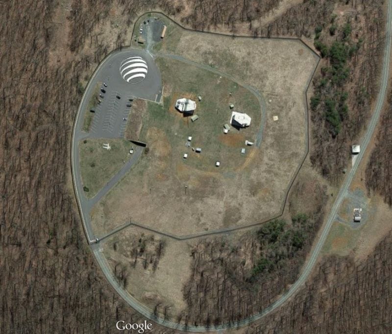
Where will the spies retreat to in the event that they fail to predict a nuclear attack? Turns out it’s another AT&T owned facility. (Are you seeing the pattern here?) This bunker is located atop another Virginia mountain called Peter’s mountain. How do we know this secret facility is owned by AT&T? It’s probably the giant logo in the parking lot. Information is limited on this site so if you would like to know more I will direct you to this article from 2015.
Airborne Assets
As shown above the U.S. Government has gone to great lengths to ensure that they (not you) will survive a black swan event & also be able to communicate after said event. In addition to these “protect & connect” facilities there are a handful of airborne assets designed to accomplish a similar role. (There are also maritime assets but they aren’t as interesting in my opinion.) There are two main types of aircraft for this role, the E-4B “Nightwatch” or “Doomsday” plane based on the Boeing 747 & the E-6B based on the Boeing 707.
E-4B
The E-4B is a specially modified 747 designed to serve as an airborne C2 center. It is designed to withstand an EMP & still be able to function as a command post. 4 E-4Bs have been built & are currently in service. Because flight data is publicly available you can track there whereabouts on ADS-B Exchange. I have included their hexes & registrations but for convenience the link below has them pre-programmed.
ADFEB3 aka E-4B 73-1676
ADFEB4 aka E-4B 73-1677
ADFEB5 aka E-4B 74-0787
ADFEB6 aka E-4B 75-0125
Fun fact E-4B 74-0787 has been used to travel to the clandestine Tonopah Test Range Airport which is located within the Nevada National Security Site. (For the uninitiated Area 51 is located within the site.)
E-6B
The E-6B is based on on the Boeing 707 & it’s purpose is to serve as a relay to launch ICBMs in the case that the other channels for this are unavailable. They are based at various bases around the U.S. & are flown by the U.S. Navy. The list below is not complete, according to Wikipedia 19 have been built. Registrations are not included because they do not follow the standard military registration format of ”XX-XXXX.”
ADS-B Exchange Link for E-6Bs.
AE040D
AE040F
AE0413
AE0414
AE0415
AE0416
AE0417
AE0418
AE041B
Considerations
The lesson here is to always be prepared for the worst. How will your team operate in the face of total annihilation? How will you respond if your entire world is falling apart around you? The key to surviving a black swan event is to take the necessary steps to mitigate the effects of said event on you, your team & your infrastructure. These steps do not need to be undertaken all at once. But these steps do need to be considered & a plan needs to be drafted to make continuous progress & improvement towards completing the actions that take your plan from idea to reality. The odds of you being fully prepared to survive a nuclear holocaust are slim. But the odds of you being able to survive 72 hours stuck in your car on the side of the road are a lot higher if you plan ahead. The point is to be more prepared than you were yesterday.
What are your support systems & what is their reliability percentage?
Are your communications secure & able to withstand disaster?
Have you included your community in these plans?
What would the effect of an internet blackout have on your operations?

